 I created the first map for my North-lands right after I wrote Troll-magic. I remember immersing myself in the feeling I had for the world, and the different moods and geographies that seemed in my mind to go with each culture, and then attempting to draw coastlines and rivers and mountains that matched my very subjective experience of the place.
It wasn’t easy at all, but it felt right. And I did manage to achieve a result close to what I wanted.
The Tally Master is set roughly 2,000 years before Troll-magic. While a few rivers have changed their courses, the basic topography of the landmass remains the same. Human elements, such as nations, fortresses, and cities – and, especially, the names for the various regions – are markedly different, of course.
I knew I wanted to include a map in The Tally Master and that I could not use the one from Troll-magic. I would need a new one!
But I like maps and drawing maps, so creating the new one was a pleasure and a treat.
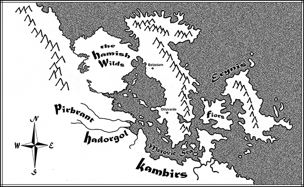
If you wish to compare the North-lands of the Bronze Age (the time of Tally Master) with that of the Steam Age (the time of Troll-magic), you can see maps of the latter here.
For more about The Tally Master, see:
Gael’s Tally Chamber in Belzetarn
Mapping Ancient Rome onto Belzetarn
What Does the Tally Master Tally?
The Fortress of Belzetarn
The Dark Tower
Belzetarn’s Smithies and Cellars
Belzetarn’s Formidable Entrance Gate
Belzetarn’s Treasures
Belzetarn’s Great Halls
Bronze Age Swords
Brother Kings

You are very visual, both in your abilities with the visual medium itself and in the language of your stories. Cool.
Thanks! I enjoy drawing (and messing about in Photoshop) and tend to indulge in the graphic arts for recreation. But, fun as that is, it does not generate the feeling of satisfaction that I get from writing.